Lidar Mapping or Lidar Mapper is a type of mapping that uses laser light to create topographical maps. It’s all based on the principle of triangulation. This was something first used in the 17th century. The basic idea is that three points are used to measure an imaginary triangle, and from there find an unknown distance by measuring the two remaining sides.

What Is A Lidar Mapper or Lidar Mapping?
Lidar, short for “light detection and ranging,” is a technology that uses light to map the surface of the Earth and can be used for land surveying, navigation, meteorology, and other applications. Lidar technology has become a valuable tool in the field of archaeology, as it allows archaeologists to study features of the landscape without disturbing them.
Lidar mapping systems are expensive and difficult to use. However, they have become more accessible in recent years as the price has come down and more companies have begun offering them as services.
A lidar mapper is a machine that uses laser pulses to scan the surface and create 3D maps of features below ground level. These maps can then be used by archaeologists and other researchers to study landscapes without having to dig up or disturb anything on site.
How Does Lidar Mapper Work?
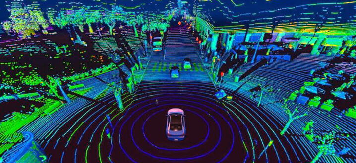
Lidar Mapper uses a method called “Lidar” which stands for Light Detection And Ranging. In order to get a detailed representation of an existing object or landscape, the program sends out pulses of light from an infrared laser that bounces off surfaces in the area. The time it takes for the pulse of light to be reflected back is recorded by the sensor. This data is used to calculate the distance between objects in relation to each other as well as their relative shape and size. The result is a point cloud that represents your surroundings in 3D form.
Function Of A Lidar Mapper?
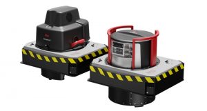
A lidar mapper is a type of mapping device that uses laser technology to generate high-resolution digital maps. A lidar mapper typically consists of a laser emitter, a scanner, and a receiver. The laser emitter shoots out pulses of light at very high speeds, which are then reflected back to the receiver by targets in the surrounding area. This data is then processed by the scanner and recorded in a digital format.
Accuracy Of Lidar Mappers?
Lidar mapping devices are highly accurate because they measure distances by calculating how long it takes for a signal to bounce back from objects in the surrounding environment. This allows for measurements with sub-millimeter precision since every pulse generates a return signal that’s also measured. Lidar mapping devices can also be used as range finders because they’re able to detect how far away objects are from them.
LIDAR Mapping Software?
LIDAR is an important technology for mapping and surveying, but it can be difficult to use. LAS software makes it easier to generate high-quality point clouds ready for 3D modeling and GIS.
What is LAS?
LIDAR (Light Detection And Ranging) is a laser-based surveying technique that measures distance by illuminating a target with laser light and analyzing the reflected pulses with detectors. The time it takes for the light to travel out, reflect off the surface, and return can be used to calculate distance. This information can be used to generate a point cloud that represents the surface of the earth in three dimensions.
LAS files use this data to create a set of points at regular intervals across space. These points correspond to discrete heights above ground level and are typically stored as X/Y coordinates in a text format called .las or .laz (depending on your operating system).
How do you use a lidar mapper?
Lidar is a remote sensing technology that uses light in the form of a pulsed laser to measure ranges (variable distances) to the Earth’s surface. Lidar has been used extensively by the military and meteorologists, and it has also been used by scientists to gather detailed information about the structure of clouds.
Lidar mapping is a relatively new use for this technology. It provides extremely detailed information about your property and surrounding areas, including topography (the shape of the land), vegetation characteristics, and soil types. Lidar maps can be used for planning purposes such as site design or environmental impact studies. They may also be used for surveying purposes such as land classification or resource assessment.
The following steps describe how to use a lidar mapper:
1) Set up your equipment on level ground within view of your property boundaries, preferably in an unobstructed area with minimal vegetation or trees nearby so you can see everything clearly from above
2) Switch on your lidar mapper, which will illuminate its array of light beams from its base unit onto the ground below it
3) Walk around with your lidar mapper while wearing earphones so you can hear instructions from its base unit.
Why integrate Lidar Mappers with other Geospatial systems?
The integration of Lidar Mappers with other Geospatial systems is one of the most powerful benefits of this technology. To understand why you need to look at how these two systems can work together.
Lidar offers data at a scale and resolution that cannot be matched by satellite or aerial imagery. The resolution of a Lidar scan is dependent on the distance between sensors along the flight path, with higher resolutions possible for shorter distances. In contrast, satellite and aerial imagery are captured from hundreds or thousands of feet above ground level, which means that they cannot offer the same level of detail as ground-based Lidar scans.
However, satellite and aerial imagery have their own strengths that make them valuable additions to any GIS database.
First: they are available in real-time (in fact they’re updated daily), so they can provide information about current conditions that LIDAR cannot provide.
Second: they cover large areas at once — meaning there are no limits on how much terrain can be captured in one pass.
Third: they have been collected over many years so they have historical context as well as current conditions.
What are the benefits of using a lidar mapper?
The benefits of using a lidar mapper are numerous. The technology provides users with a detailed view of their surroundings, which is useful for many different purposes. From construction companies to geologists, there are many people who can benefit from this technology.
Benefits of Lidar Mapping:
1. Accuracy- Lidars are able to measure distances with an accuracy of between 0.15mm and 5mm depending on the type of device used. This makes them ideal for mapping large areas where there is a need for high levels of detail, such as construction sites or archaeological projects.
2. Speed – Lidars can scan up to 1 million points per second and this speed means that large areas can be mapped quickly, making it ideal for urban planning or environmental surveys.
3. No Distortion – Unlike aerial photography or satellite imagery, lidar scans are not affected by atmospheric conditions so there is no distortion in the final map product due to cloud cover or haze, etc.
Benefits for Construction Companies:
One of the most obvious benefits of using a lidar mapper is that it can help construction companies save money by reducing the need for costly site visits or surveys. When you use this type of technology, you can get a digital 3D model of your entire site and use it to plan out your project before beginning construction. This means that you’ll have an accurate picture of what’s on your property and be able to avoid any surprises that could come up during the building process.
Conclusion:
Not many people have heard of lidar or even know what it is, but the technology is constantly improving. Lidar mappers have been able to map the world at a much higher resolution than ever before, and they will continue to do so in the future. Technology has helped scientists and researchers study our planet more effectively than we could have ever imagined. It has also helped us explore space, which will help us find new planets that we can colonize someday.