Imagine if you could accurately map the structure of the seabed from thousands of feet in the air. Sounds too good to be true, right? Well, it’s possible with bathymetric lidar sensor technology.
You may not know it, but lidar sensors are becoming one of the most revolutionary and powerful tools in aircraft surveying today. And that’s because they measure elevation quickly and accurately by using light, rather than sound or gravity waves like traditional bathymetric methods of seafloor mapping.
But how does it all work? In this article, we’ll explain which light bathymetric lidar sensors use and why aircraft need them. We’ll also share insight into their most common applications and describe how they can benefit various industries. Let’s dive in!
What Is Bathymetric Lidar Sensor?
If you’ve ever wondered why aircraft need bathymetric lidar sensors, here’s why: they are used to provide data on the depth of oceans, rivers, and other bodies of water. This is important because data on the depths of these bodies of water is needed to create nautical charts that help ensure safe navigation.
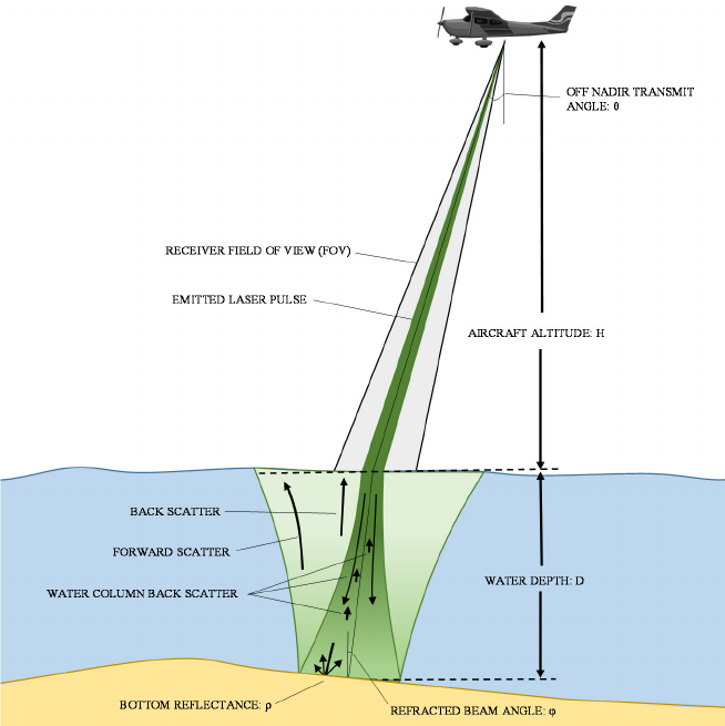
The lidar sensor emits a pulse of light and measures the time it takes for the light to return. That time tells us the distance between the sensor and the object, which in turn gives us a measure of depth. The ability to measure topographical elevation and underwater depth makes it an ideal tool for creating accurate nautical charts.
In addition to being used for navigation, bathymetric lidar can also be used for surveying coastlines and mapping seabeds. It is also starting to be used for more specialized purposes such as ocean engineering projects, pollution research, and coral reef monitoring.
What Light Does Bathymetric Lidar Use?
In order to accurately measure water depths and terrain quickly and effectively, aircraft use bathymetric Lidar sensors. Bathymetric Lidar is a combination of Light Detection and Ranging (Lidar) technology with bathymetry to measure water depths.
Bathymetric Lidar uses green light in the visible spectrum; that means the sensor’s laser sends out pulses of green light which will then be reflected back by the terrain being scanned. The data from these reflections are then used to create a detailed map of the terrain below, including depth information about bodies of water.
The advantage of using green light is that it penetrates further into the water than other frequencies, making it better at capturing deeper depths that standard bathymetry methods may miss. Additionally, green light scatters less off suspended particles than other wavelengths, such as blue ones, reducing inaccuracies caused by suspended sediment or algae in the water column.
How Does Bathymetric Lidar Work?
You might be wondering how bathymetric lidar works. Put simply, it uses two different light sources to send out laser pulses and measure backscatter from the water’s surface. The first light source emits short laser pulses that penetrate the water and measures the exact depth of seabeds and underwater hills, valleys, and other features. The second light source produces long-wave infrared pulses that measure the water’s surface elevation.
By combining both measurements, a 3D map of any given region can be made that’s highly accurate. This information is a vital resource for coastal monitoring, hydrology research, and other activities related to the maritime environment.
The reason aircraft require these bathymetric lidar sensors is that they provide more detailed measurements than traditional survey techniques such as single beam echo sounders or acoustic-optical systems. This makes them much more effective for capturing data about seabeds and surfaces in ways manual surveys cannot compare.
Benefits of Using Bathymetric Lidar Sensor on Aircraft
You might be wondering why aircraft are fitted with bathymetric lidar sensors, and the answer is simple: they offer a number of useful benefits.
Cost savings
Using a bathymetric lidar sensor on an aircraft is much more cost-effective than other methods of surveying the ocean floor. An aircraft fitted with a bathymetric lidar sensor can map large areas in short time periods, which means that it can be used for multiple surveys in the same amount of time that it would take to do one survey using traditional methods. Plus, the data gathered from a bathymetric lidar sensor is more accurate and can be processed faster than other types of data.
Reduced safety risks
Since a bathymetric lidar sensor doesn’t require people to enter the water, there’s no risk of personal harm during surveys. This also eliminates the need for costly safety equipment since there’s no need to worry about divers getting injured or lost during their surveys. The data gathered from a bathymetric lidar sensor is also easier to store and analyze, meaning fewer errors when it comes to interpreting results.
In addition to the cost savings and safety benefits, the data gathered from a bathymetry lidar sensor can be used for further research purposes, such as studying ocean currents or marine life behavior. This type of research produces valuable information that can be used to develop better ocean management techniques or conservation policies that could help preserve our marine lidar ecosystems for future generations.
Examples of How Bathymetric Lidar Sensors Are Used on Aircraft
So, why do aircraft need bathymetric lidar sensors? Well, take a look at some of the ways they’re used.
Marine Surveying
By using bathymetric lidar sensors, aircraft can be used to survey large areas of water in a short amount of time. Bathymetric lidar sensors are able to detect the depths and shape of the ocean floor, making them a highly efficient way to conduct surveys. This means cheaper and quicker marine surveying for your project.
Oil and Gas Exploration
Another example is oil and gas exploration. Aircraft equipped with bathymetric lidar sensors are used to create detailed maps of the ocean floor so that geologists can look for possible petroleum deposits.
Ocean Mapping
Lastly, bathymetric lidar sensors on aircraft are great at creating detailed maps of the ocean floor. These maps are then used for navigation purposes, aiding ships in getting from one location to another or helping with search and rescue operations.
Challenges of Using Bathymetric Lidar With Aircraft
Have you ever wondered what light a bathymetric lidar sensor use, and why aircraft need them? Well, here is the answer!
Aircraft use bathymetric lidar sensors because they can collect data from a larger area in less time than traditional surveying methods. Lidar sensors emit laser pulses that can measure depth and distance with extreme accuracy. These sensors work best when the beam of light is able to travel far distances with minimal distortion. This is why aircraft are ideal for using this type of sensor—they are able to fly over vast bodies of water and map their depths with ease.
The challenges of using this type of sensor on an aircraft don’t stop there – getting the right amount of power and optimizing the beam profile to maintain accuracy takes a lot of careful planning. But when it comes to surveying large bodies or water efficiently, the aircraft is your best bet.
Conclusion
In the end, bathymetric lidar sensors are key tools in surveying, collecting data, and creating detailed maps of areas inaccessible to other methods. They’re invaluable for everything from studying bathymetry and navigational hazards to creating 3D maps for use in mapping and construction.
Whether you’re looking to keep track of a harbor or map an entire lake, you can use bathymetric lidar sensor data to get a comprehensive overview of the area and move forward with confidence. With the right data, anyone can make informed decisions on any type of aquatic project.