Before starting how in 2D Lidar and how work? Let me tell you what is LIDAR technology.
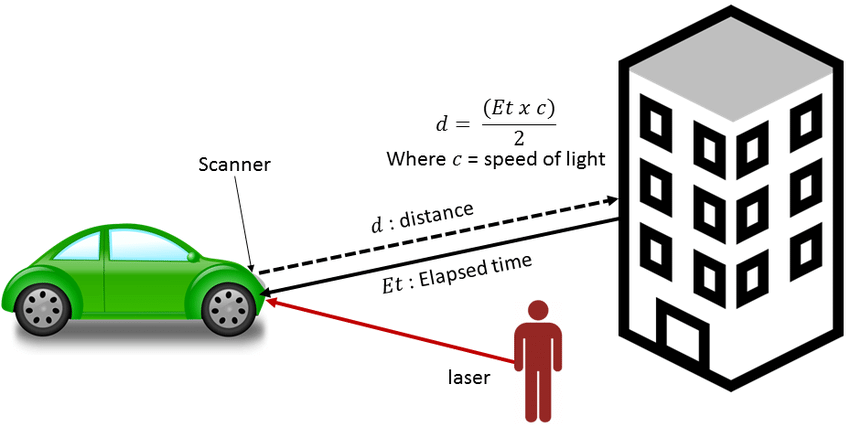
LIDAR technology uses sensors to illuminate light to accurately measure distances between objects. When the illuminated light bounces off the target object and is reflected back to its source, it gives accurate information about its velocity and distance. Airborne light has a constant speed, enabling accuracy.
What is 2D Lidar
2D Lidar is a sensing technology that measures the distances and shapes of objects. Lidar stands for Light Detection and Ranging. It emits a laser beam and measures the time it takes for the beam to bounce back off of an object.
This information can be used to calculate the distance to an object. They are often used in robotic applications, such as in self-driving cars, to help the robot navigate its environment and avoid obstacles.
How does 2D lidar work?
2D lidar technology works by sending out a laser pulse and then measuring the time it takes for the pulse to bounce back off a nearby object. By knowing the speed of light and the time it takes for the pulse to return, the distance to the object can be calculated. This process is then repeated many times per second, allowing the lidar system to build up a 3D map of its surroundings.
They are used in a variety of applications, including self-driving cars, robotics, and mapping.
What are the benefits of using 2D lidar?
2D lidar sensors offer a number of advantages over traditional 2D imaging systems.
They are able to provide accurate distance measurements even in low-light conditions, making them ideal for use in autonomous vehicles and other applications where traditional imaging systems would struggle.
Additionally, they can provide distance measurement at a much higher resolution than traditional imaging systems, making them ideal for use in applications where precise distance measurement is required.
How is 2D LiDAR different from other types of lidar?
2D LiDAR is different from other types of lidar in a few key ways.
For one, they have a much higher point density than other types of lidar, meaning that they can capture more data points in a given area. This makes LiDAR ideal for applications where a high degree of detail is needed, such as mapping or surveying.
Additionally, 2D LiDAR systems tend to be smaller and more lightweight than other types of lidar, making them more portable and easier to use in a variety of settings.
What applications can 2D LiDAR be used for?
2D LiDAR can be used for a variety of applications, including mapping and surveying, object detection and tracking, and even 3D reconstruction.
When used for mapping and surveying, it can provide accurate, high-resolution data that can be used to create detailed maps. Object detection and tracking applications make use of 2D LiDAR’s ability to rapidly scan an area and identify objects, while 3D reconstruction applications utilize their capability to capture detailed 3D data to create accurate models of objects or environments.
FAQ: 2D LiDAR
How can 2D LiDAR detect obstacle detection?
2D LiDAR can detect obstacles by emitting a laser beam and measuring the time it takes for the beam to reflect off of an object. The reflected beam is then received by the LiDAR sensor, which calculates the distance to the object based on the time it took for the beam to return. This information can be used to detect and avoid obstacles.
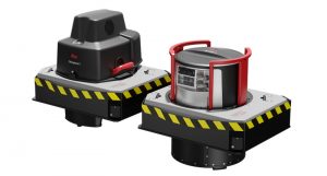
What is a 2D laser scanner?
2D laser scanners are devices that emit a laser beam in order to collect measurement data. 2D laser scanners are used in a variety of applications, such as 3D scanning, object detection, and material classification.
What is 3D LiDAR?
3D LiDAR, or Light Detection and Ranging, is a technology that uses laser pulses to measure distance. It is used in a variety of applications, including surveying, mapping, and navigation. 3D LiDAR can be used to create highly accurate 3D models of objects and environments. It is often used in conjunction with other technologies, such as GPS, to create detailed and accurate maps. 3D LiDAR can also be used for navigation, particularly in difficult or dangerous environments. It can be used to create virtual maps of an area, which can be used to plan routes and avoid obstacles.
Read This: 3D Laser Scanning Services For Architecture And Construction
What is a LiDAR scanner used for?
A LiDAR scanner is a type of remote sensing technology that uses laser pulses to map the surface of an area. LiDAR stands for Light Detection and Ranging, and the technology is used in a variety of applications, including topographic mapping, archaeology, and atmospheric studies.
What are the three basic types of LiDAR?
A LiDAR scanner is a type of remote sensing technology that uses laser pulses to map the surface of an area. LiDAR stands for Light Detection and Ranging, and the technology is used in a variety of applications, including topographic mapping, archaeology, and atmospheric studies.