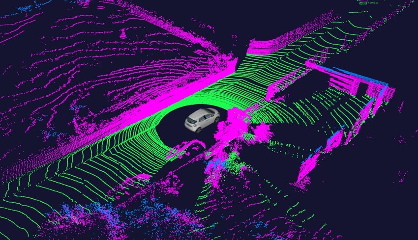
A point cloud is a collection of points used to create a computer representation of a physical location or object in three dimensions. It comprises countless numbers of x, y, and z-coordinated measurement points. A 3D point cloud is an extremely precise digital representation of an item. The 3D point cloud is used to create 3D meshes and other models for 3D modeling. The 3D point cloud is widely used in many engineering and medical disciplines, including medical imaging, 3D printing, manufacturing, architecture, 3D gaming, and virtual reality applications.
Each point may also contain RGB color data or intensity information depending on the sensors employed and the technique utilized to collect the cloud. These numbers show the laser pulse’s return power, which produced the point. Keep in mind that each 3D point cloud always contains points that are situated on the visible objects’ exterior surfaces. These spots are caused by reflections of the scanner’s light rays from the object.
The object representation is more detailed and can capture even tiny details the denser the points are in the point cloud. 3D Point cloud processing is the method used to transform these point cloud data into a 3D representation. The quantity and density of scans needed determine how long it takes to construct a point cloud. When compared to advanced scanners, the typical mobile scanner is substantially faster.
Point Cloud Generation
Any of the two tools listed below can be used to capture a point cloud:
- Photogrammetry
- Laser Scanners
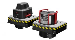
3D Point Cloud Laser Scanners
A laser scanner uses a variety of sensors and cutting-edge technology to collect millions of incredibly precise measurements every second. Additionally, an RGB camera and an inertial measurement unit are present to give the point cloud color. For a certain range of applications, various types of laser scanners are manufactured. The maximum level of accuracy is provided by a terrestrial laser scanner. As a result, they are employed in specific tasks like measuring beam deflection, capturing a single object like a car or equipment, or precisely examining the flatness of a floor.
Point clouds can be recorded using mobile laser scanners with an accuracy of up to 4mm. These mobile scanners will be useful for standard building documentation projects, mapping active areas like factories, etc. where great accuracy is not required. Typically, laser scanners offer data with a higher degree of accuracy than photogrammetry.
Read also: While Using Laser Scanners top 3 mistakes to avoid
Using Photogrammetry to create 3D Point Clouds
A 3D point cloud is generally created using photogrammetry. In this method, cameras are used to take pictures of the area or object from every aspect. Then, using specialized software, the photographs are processed to create a 3D reconstruction of the area or object. 3D point cloud is frequently captured by drones.
Point Cloud Features
Point clouds’ primary technical features include:
- In 3D, point clouds only offer information about an object’s position, dimensions, and geometry. They do not, however, provide the remaining details about the object that the user needs to know.
- The point cloud that results from scanning frequently includes a lot of undesired components, such as scaffolding, shadow areas, work equipment, steam clouds, etc. To prevent problems, these must be cleaned.
- An “As-built” is fundamentally composed of a point cloud. Documents and material lists on paper are complemented by the point cloud system.
- The scanner’s quality is crucial since it aids in finding, recognizing, and taking references to things in the captured spherical image or bubble view.
- All existing work, such as overhauling, extensions, and dismantling, can be done with the 3D Scanner tool.
- The point cloud generation formats employed must be manageable and exportable in various design and visualization applications, including Smart Plant 3D, E3D, MicroStation, PDS, and AutoCAD.
- A point cloud system creates an exact replica of an existing object.
Point Cloud Applications
Point cloud has enormous utility in a wide range of applications because it offers an accurate, thorough, and exact digital image of a genuine item. Several of the most popular applications include:
Building Information Modeling: Accurate and thorough models can be produced by processing the point cloud data in specialized BIM modeling software.
Tracking construction Progress: Any plant’s construction progress can be easily monitored by routinely collecting point cloud data.
Creation of operational 3D models: To create a functional 3D model of any asset, point clouds are often employed.
Floor Planning: A floor plan for any structure may be simply created using point clouds.
Inspection and Measurement: Point clouds are also utilized for a variety of visualization, rendering, animation, and mass customization applications, as well as for metrology and quality inspection, creating 3D CAD models for produced parts, checking deformations over time, etc.
As-Built: The designer or architect can envision and communicate fresh concepts thanks to point cloud software, which eliminates expensive and time-consuming site visits. Since it provides a quick virtual model to test ideas on, point clouds have gained popularity across many design industries.